Quiet weather and pleasantly cool temperatures to close out the week
Look for sunshine on Friday but highs remaining in the 60s
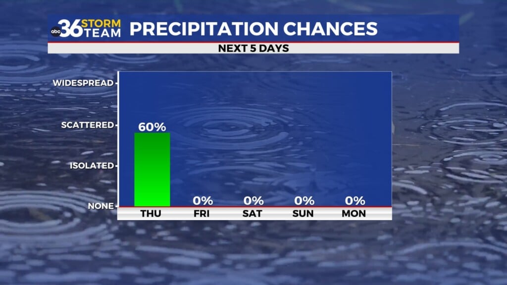
It’s been anything but typical May weather across Central and Eastern Kentucky this week. Thursday brought a good deal of sunshine, but the standout story was the continued chill in the air, especially across the northern half of the state where the cloud deck was a little more widespread. Thanks to a stubborn upper-level low spinning to our northeast, a persistent northwest wind kept cooler-than-average temperatures locked in across the region. Afternoon highs barely cracked the mid-60s in the Bluegrass, running 10 to 15 degrees below where we should be this time of year while our southern counties saw more sunshine and highs around 70 degrees. Add in the breeze, and it felt even cooler—especially in areas with more cloud cover.

A Cool But Pleasant Finish to the Week
Friday is shaping up to be another quiet and comfortable day, though still on the cool side for late May. As that upper low begins to drift farther east into New England, high pressure will start to build in from the west. Expect more sunshine and dry conditions, but don’t forget a jacket for the morning hours—lows will start off in the low to mid-40s. That cool air mass sticks with us into the afternoon, with highs only managing the mid to upper 60s despite the sunshine. The northwest breeze will hang around, continuing to hold temperatures below seasonal norms.

Saturday: The Best Day of the Holiday Weekend
If you’re trying to decide when to plan outdoor activities this Memorial Day weekend, Saturday is hands down your best bet. High pressure will still be in control, providing more sunshine and dry air across the region. Highs should finally nudge closer to 70°, making it feel a bit more like May—though still technically a few degrees below normal. A warm front just to our southwest will stay in place through the day, but rain chances hold off until later Saturday night.

Rain Returns Late Sunday and Memorial Day
The second half of the holiday weekend turns more unsettled as that stalled warm front begins to drift north and a developing low pressure system moves in from the Plains. Expect a bit more shower activity to return Sunday, mainly across our southern counties with cooler air still hanging tough and highs likely stuck in the 60s. Being north of the boundary, we are looking at mainly rain showers as the better storm chances stay across the Mid-South.


By Memorial Day, rain chances increase further as the low passes close to the region. With the warm front nearby and some modest instability possible, a few storms should mix in—but severe weather isn’t expected at this point, but it bears watching given that it is late May. Rainfall totals could range from 1 to 2 inches, with locally higher amounts possible. Given already elevated river levels in some areas, localized flooding will be something to watch.

Cool, Damp Weather Lingers Into Next Week
Unfortunately, it doesn’t look like we’ll shake this cool, damp pattern anytime soon. As the upper-level trough settles over the eastern U.S., Central and Eastern Kentucky will stay under its influence into the middle of next week. That means continued shower chances and temperatures that remain below average, with highs generally in the upper 60s to low 70s. It’s a stubborn setup, but signs of a warmer and drier pattern to start June may finally be on the horizon.

Thursday Night: A few clouds and chilly. Lows in the low to mid-40s. Wind: NW 5-10 mph.
Friday: Mostly sunny and pleasant. Highs in the mid-60s. Wind: NW 5-10 mph.
Friday Night: Fair skies, another chilly night. Lows in the low to mid-40s. Wind: W 5-10 mph.